
$1,056,764
Farm, Newton Lane, Tattenhall, Chester, Cheshire
- 4 Beds
- 1 Baths
- 1,820 Sqft
- 7.97 Ac lot
- Updated: Today
- 3
About the Property
The Property
A former dairy farm offering a diverse range of alternative uses such as equestrian, a private residential property or development, subject to planning consent. The property extends to approximately 7.97 acres (3.23 ha), with an additional 12.26 acres (4.96 ha) by separate negotiation.
Lot 1
The Farmhouse
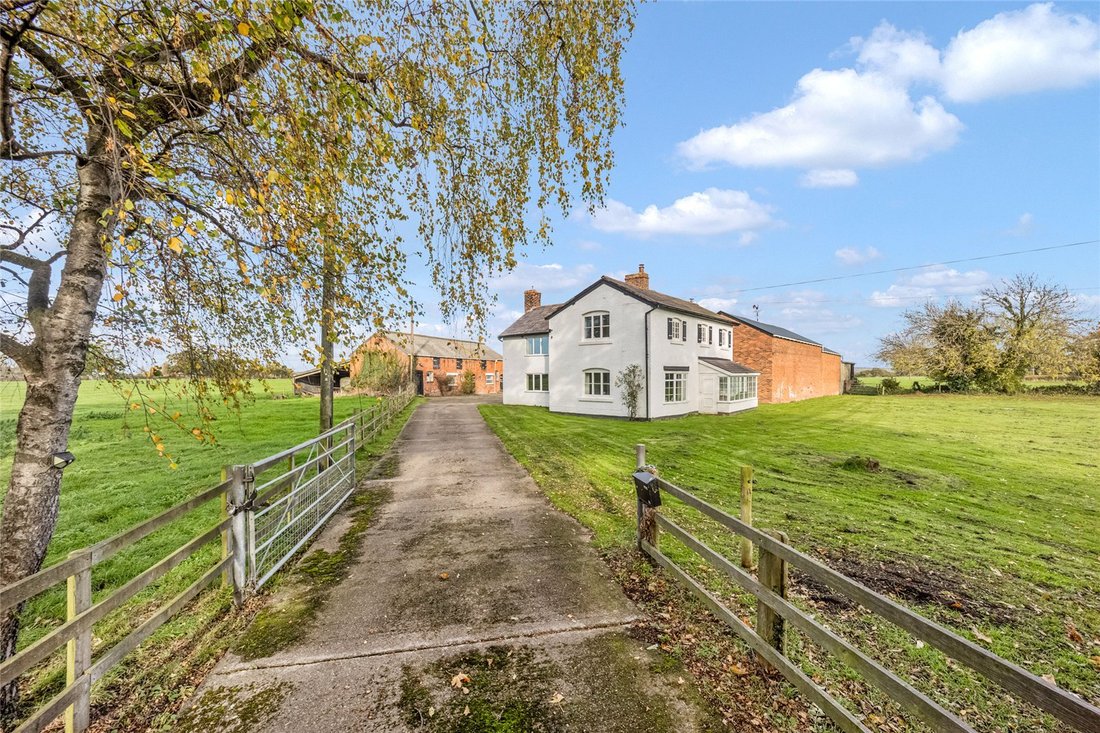
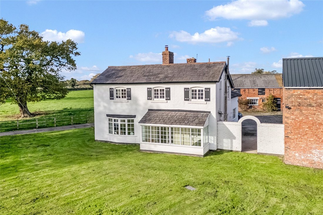
A substantial whitewashed brick-built farmhouse
The Property
A former dairy farm offering a diverse range of alternative uses such as equestrian, a private residential property or development, subject to planning consent. The property extends to approximately 7.97 acres (3.23 ha), with an additional 12.26 acres (4.96 ha) by separate negotiation.
Lot 1
The Farmhouse
A substantial whitewashed brick-built farmhouse under natural slate roofing, requiring a general scheme of refurbishment throughout, with the possibilities of extending, STP.
The accommodation is arranged over two floors offering extensive living space, perfect for growing families. (See floorplan for accommodation layout).
Outbuildings
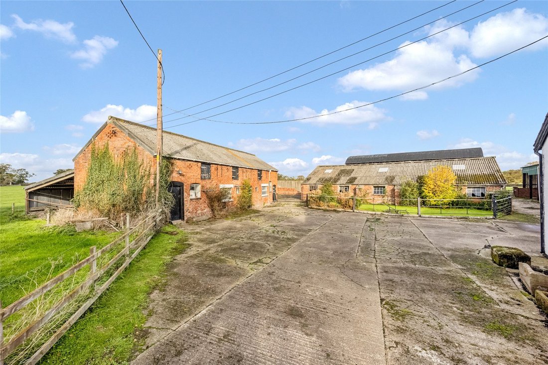
The property benefits from a substantial range of brick and steel-framed, clad buildings, comprising the following:
Detached building – 2-storey brick-built with corrugated fibre roof, with an adjoining corrugated covered yard to the rear, extending to approx. 1926 sq. ft (brick building only).
Brick Shippon – a single storey building with 30 stalls, and a steel-framed covered yard linking to a Dutch barn and a further covered yard to the rear. Approx 6187 sq. ft in total.
Detached building – 2-storey brick-built with profile metal sheet roofing, with an adjoining steel-framed pent-roof shed with partial Yorkshire boarding. Approx. 3751 sq. ft in total.
Sileage clamp – with pre-cast concrete walls and concrete flooring.
Farmland
The land within Lot 1, edged red on the sales plan, comprises of approximately 7.97 acres (3.23 ha) of Grade 3 grazing land (according to Provisional Agricultural Land Classification (ALC) (England)). Slowly permeable seasonally wet slightly acid but base-rich loamy and clayey soils. It has water troughs with over-land mains water. Access from the farm driveway, with road frontage.
There is an additional 12.26 acres (4.96 ha) of Grade 3 grazing land, as edged blue on the plan, available by separate negotiation.
Situation
Tattenhall is a picturesque Cheshire village about eight miles southeast of Chester, known for its medieval origins recorded in the Domesday Book, its historic centre around St Alban’s Church, and a landscape of redbrick cottages, Georgian farmhouses, and rolling countryside.
It is a thriving rural community with shops, pubs, cafés, strong local services, the well-known Cheshire Ice Cream Farm and access to the Sandstone Trail.
Tattenhall Park Primary School is a “good” state school and is a feeder to Bishop Heber High School, Malpas, an Ofsted “Outstanding” state secondary school.
Tattenhall is a charming blend of heritage, community life, and modern rural appeal.
Fixtures and fittings
All fixtures, fittings and furniture such as curtains, light fittings, garden ornaments and statuary are excluded from the sale. Some may be available by separate negotiation.
Additional Land Available
There is an additional area of land extending to approximately 12.26 acres (4.96 ha) that is available by separate negotiation. The land in question is edged blue on the plan.
Services
Mains water and electricity (3-phase to the detached brick barn). Private drainage and oil-fired central heating. None of the services or appliances, heating installations, plumbing or electrical systems have been tested by the selling agents.
If the private drainage system requires updating/replacement, it is assumed that prior to offers being made, associated costs have been considered and are the responsibility of the purchaser. Interested parties are advised to make their own investigations, no further information will be provided by the selling agents.
The estimated fastest download speed currently achievable for the property postcode area is around 1800 Mbps (data taken from [hidden information] on 30/01/2026). Actual service availability at the property or speeds received may be different.
We understand that the property is likely to have current mobile coverage (data taken from [hidden information] on 30/01/2026). Please note that actual services available may be different depending on the particular circumstances, precise location and network outages.
Tenure
Freehold with vacant possession on completion, subject to a grass crop agreement, in place until June 2026.
Development Overage
An uplift will be applied to the whole of the property in the event of approval for any additional residential dwellings, at 40% over 25 years, triggered by the implementation of planning or an onward sale with the enhanced benefit.
Rural, Environmental and Woodland Schemes
The land is not believed to be subject to any ongoing schemes.
Method of sale
The property is offered for sale by Private Treaty method. However the vendor reserves the right to conclude the sale by an alternative method if required.
Local Authority
Cheshire West & Chester Council
Council Tax Band: E
Public rights of way, wayleaves and easements
The property is sold subject to all rights of way, wayleaves and easements whether or not they are defined in this brochure.
Planning
The vendors do have recent ecology reports and surveys, which can be shared following discussions with the vendors.
The selling agents will not provide advice/guidance on the planning history for the property/land. Interested parties are advised to make their own investigations. It is assumed that enquiries have been satisfied, prior to an offer being made.
Anti Money Laundering Regulations (AML)
In accordance with Anti Money Laundering Regulations (AML), we are required to request forms of identification and carry out due diligence on any parties connected to a successful offer. Should an offer be made on behalf of a business/company, AML due diligence will also be necessary. Proof/source of funding must be supplied, prior to offer acceptance.
Plans and boundaries
The plans within these particulars are based on Ordnance Survey data and provided for reference only. They are believed to be correct but accuracy is not guaranteed. The purchaser shall be deemed to have full knowledge of all boundaries and the extent of ownership. Neither the vendor nor the vendor’s agents will be responsible for defining the boundaries or the ownership thereof.
In the event that the buyer of Lot 1 does not
purchase the additional land, edged blue, the
buyer will be responsible for erecting and
maintaining the new boundary splitting the
two parcels of land.
Viewings
Strictly by appointment through Fisher German LLP.
Directions
Postcode – CH3 9AY
what3words – ///[hidden information]
-
Property type
Farm Ranch
-
Price/sqft
$580
-
Consumption
F
Features
Explore the Area
Newton Lane, Tattenhall, Chester, Cheshire, Cheshire West and Chester, England
View on Google Maps
Price per sqft
Low
High
Joined 2 years ago
You have inquired about this property
The agent will contact you soon by
Listed by
Fisher German – Chester
View agency profile
46
Listings
2024
Joined
Book home tour with the agent
Choose a date and whether you'd like a virtual or in-person tour with the agent.
Preferred date
Tour type
Fisher German – Chester
View agency profile
Last updated
Today
First listed
February 5
Listing reference
CHS250178
Similar Properties Nearby
New Listings in Cheshire West and Chester



Explore More Homes for Sale
Cheshire West and Chester cities
- Homes for sale in Cheshire
- Homes for sale in Malpas
- Homes for sale in Antrobus
- Homes for sale in Backford
- Homes for sale in Delamere
- Homes for sale in Duckington
- Homes for sale in Great Budworth
- Homes for sale in Neston
- Homes for sale in Tarporley
- Homes for sale in Tilston
- Homes for sale in Willington
Cheshire West and Chester property types
Cheshire West and Chester popular searches
- Panoramic / Scenic View properties in Cheshire West and Chester
- Lake View properties in Cheshire West and Chester
- Properties with Terrace in Cheshire West and Chester
- Properties with Bar in Cheshire West and Chester
- Properties with Game Room in Cheshire West and Chester
- Properties with Office in Cheshire West and Chester
- Mountain View properties in Cheshire West and Chester
- Properties with Garden in Cheshire West and Chester
- Properties with Outdoor Kitchen in Cheshire West and Chester
- Gated Community properties in Cheshire West and Chester
- Privacy properties in Cheshire West and Chester
- Investment Property properties in Cheshire West and Chester
- Modern properties in Cheshire West and Chester
- Equestrian properties in Cheshire West and Chester
- New Builds properties in Cheshire West and Chester
- Properties with Fitness Center / Gym in Cheshire West and Chester
- Properties with Sauna in Cheshire West and Chester
- Properties with Library in Cheshire West and Chester
- Properties with Air Conditioning in Cheshire West and Chester
- Properties with Wine Cellar in Cheshire West and Chester
- Properties with Jacuzzi in Cheshire West and Chester
- Properties with Fireplace in Cheshire West and Chester
- Properties with Pool in Cheshire West and Chester
- Properties with Garage in Cheshire West and Chester
- Properties with Balcony in Cheshire West and Chester
- Properties with Tennis Court in Cheshire West and Chester
- Properties with Open Kitchen in Cheshire West and Chester
- Renovated properties in Cheshire West and Chester
- Properties with Cinema in Cheshire West and Chester
- Properties with Indoor Pool in Cheshire West and Chester
- Water View properties in Cheshire West and Chester
Cheshire West and Chester neighborhoods
- Homes for sale in Handbridge
- Homes for sale in Heron Bridge
- Homes for sale in Heronbridge
- Homes for sale in Pulford
- Homes for sale in Abbots Meads
- Homes for sale in Abbotts Mead
- Homes for sale in Aldersey Green
- Homes for sale in Bache
- Homes for sale in Balmoral Park
- Homes for sale in Barnhill
- Homes for sale in Blacon
- Homes for sale in Broughton Heath
- Homes for sale in Brown Knowl
- Homes for sale in Cassia Green
- Homes for sale in Chester Castle
- Homes for sale in Clive
- Homes for sale in Cotebrook
- Homes for sale in Curzon Park
- Homes for sale in Eaton Hall
- Homes for sale in Flookersbrook
- Homes for sale in Garden Lane
- Homes for sale in Hand Green
- Homes for sale in High Billinge
- Homes for sale in Hockenhull
- Homes for sale in Hoole
- Homes for sale in Horton Cum Peel
- Homes for sale in Hough Green
- Homes for sale in Huxley
- Homes for sale in Lache Park
- Homes for sale in Lache
- Homes for sale in Laylands Green
- Homes for sale in Little Saughall
- Homes for sale in Mold Junction
- Homes for sale in Newton by Chester
- Homes for sale in Nomans Heath
- Homes for sale in Oulton Park
- Homes for sale in Roodee
- Homes for sale in Ruloe
- Homes for sale in Tarvin Bridge
- Homes for sale in The Bars
- Homes for sale in The Maples
- Homes for sale in Upton by Chester
- Homes for sale in Vale Royal
- Homes for sale in Westminster Park
- Homes for sale in Wharton Green
- Homes for sale in Wharton
Related Guides & Stories
Trusted by the World's Leading Brokers
The agents behind the world's most exceptional properties list with JamesEdition.
- Listings from Sotheby's, Christie's, BARNES, and Engel & Völkers
- Every listing reviewed before it goes live
- Connect directly with verified listing agents
By continuing you agree to our Terms and Privacy Policy.