$1,500,000
Penedo`s Island, Brasilien
- 678.0 Ac lot
- Aktualisiert: Oktober 2
Über die Immobilie
Beschreibung wurde automatisch übersetzt.
Die Beschreibung wird in der Originalsprache angezeigt.
Riesige private Halbinsel/Insel, perfekt für ein Öko-Resort - ein Traumparadies für Naturliebhaber
Die Halbinsel/Insel Penedos befindet sich in der Gemeinde Caravelas im äußersten Süden von Bahia (am Tor zum Albrolhos Marine National Park). Laut der NGO International Conservation ist dies die „[Meeres-] Region mit der höchsten biologischen Vielfalt, die im Südatlantik verzeichnet wurde“ u
Die Halbinsel/Insel Penedos befindet sich in der Gemeinde Caravelas im äußersten Süden von Bahia (am Tor zum Albrolhos Marine National Park). Laut der NGO International Conservation ist dies die „[Meeres-] Region mit der höchsten biologischen Vielfalt, die im Südatlantik verzeichnet wurde“ u
Huge private peninsula/island perfect for an eco resort - a dream paradise for nature lovers
The Peninsula/Island of Penedos is located in the municipality of Caravelas in the far south of Bahia (at the gateway of the Albrolhos Marine National Park). According to the NGO International Conservation, this is the “[marine] region with the highest biodiversity recorded in the South Atlantic”
The Peninsula/Island of Penedos is located in the municipality of Caravelas in the far south of Bahia (at the gateway of the Albrolhos Marine National Park). According to the NGO International Conservation, this is the “[marine] region with the highest biodiversity recorded in the South Atlantic”
Riesige private Halbinsel/Insel, perfekt für ein Öko-Resort - ein Traumparadies für Naturliebhaber
Die Halbinsel/Insel Penedos befindet sich in der Gemeinde Caravelas im äußersten Süden von Bahia (am Tor zum Albrolhos Marine National Park). Laut der NGO International Conservation ist dies die „[Meeres-] Region mit der höchsten biologischen Vielfalt, die im Südatlantik verzeichnet wurde“ und das fischreichste Gebiet Bahias. Zwischen Juli und Oktober besuchen Buckelwale das Gebiet, um zu brüten und die Kälber zu füttern. Die 18 Meter langen und 40 Tonnen schweren Tiere verzaubern die Besucher mit einer aufregenden Akrobatikshow mit Sprüngen und Pirouetten.
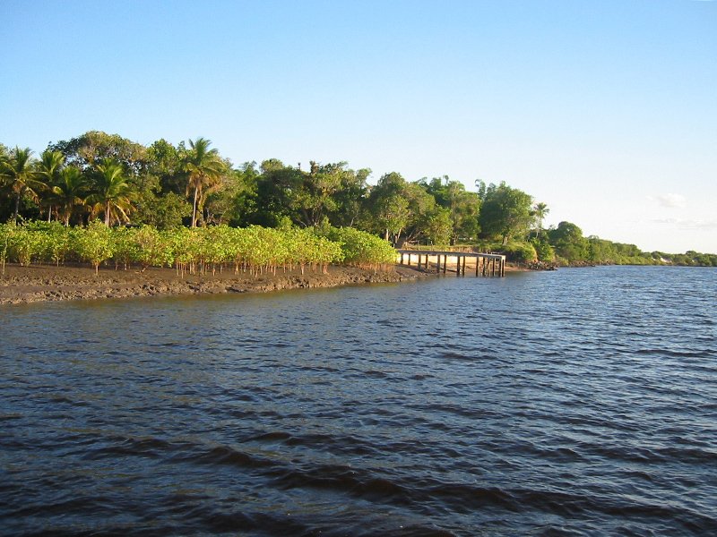
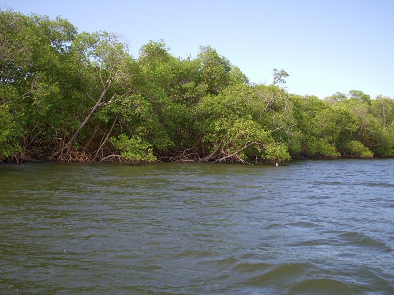
Die Halbinsel/Insel (Höhe 2 bis 6 m) ist in eines der größten Mangrovengebiete Brasiliens integriert. Sie befindet sich am Ende der Halbinsel zwischen den Flüssen Pit und Cupid.
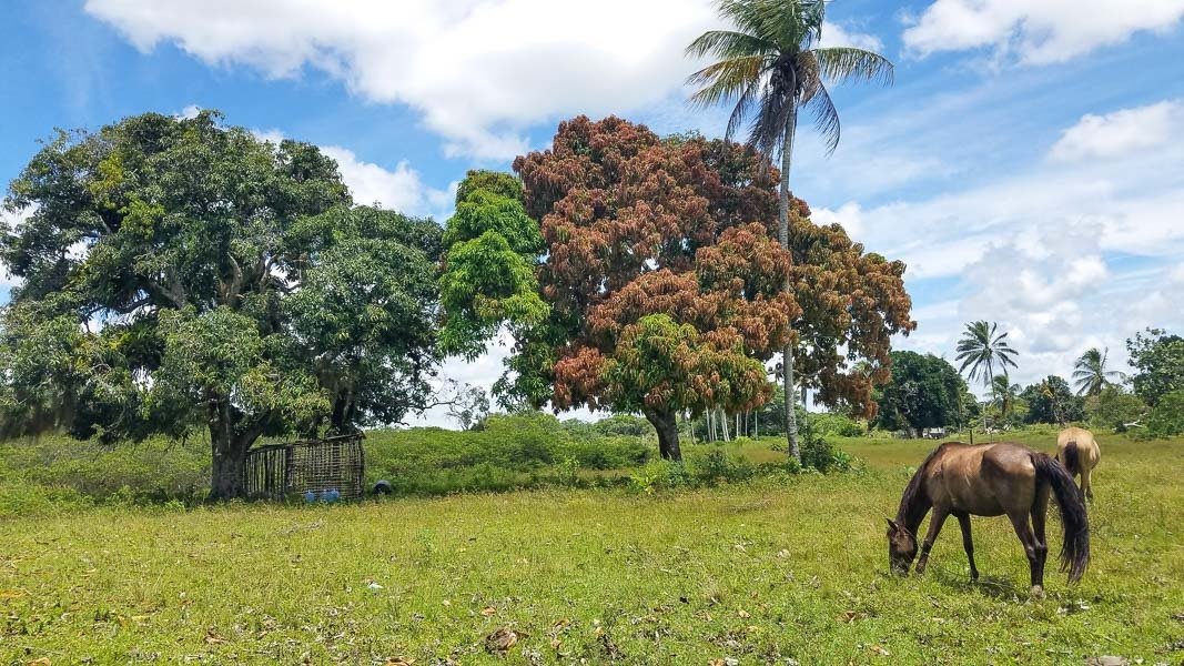
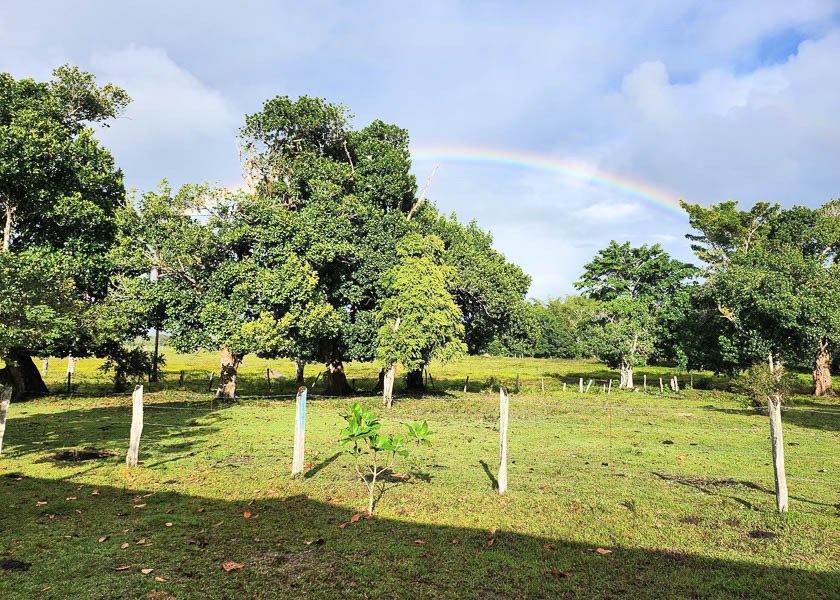
Insgesamt hat die Halbinsel/Insel Penedos eine Fläche von 274,39 Hektar, davon 243,28 Hektar mit Titeln (Farm von Marobá: 13,77 Hektar, Meeresfläche: 17,35 Hektar). Die Insel hat eine gemischte Vegetation aus Gräsern und großen Bäumen. Darüber hinaus gibt es eine Vielzahl von Obstbäumen (Jackfrucht, Mango, Kokosnuss, Orange, Zitrone usw.). An seiner Ostgrenze beträgt das Mangrovengebiet etwa 180 Hektar und der Südhang etwa 40 Hektar. Auf der Westseite befindet sich auch ein Teich mit etwa 10 Hektar.
Die Insel Penedos liegt 10 Minuten mit einem kleinen Boot vom Festland, der Tankstelle, dem Stadtzentrum und vielem mehr entfernt.
Aktuelle Infrastruktur:
- Drei kleine Backsteinhäuser — mit Solarplatten/Batterie für Beleuchtung und Funkkommunikation. Es gibt Dieselmotoren, um Wasser zu pumpen und bei Bedarf Strom zu erzeugen.
- Zwei überdachte Servicehallen — für Traktoren, Werkzeuge, Ausrüstung usw.
- Ein artesischer Brunnen — Süßwasser von ausgezeichneter Qualität, das in einer 10.000 Liter fassenden Glasfaserbox aufbewahrt und über Leitungen verteilt und verbraucht wird
- Viehzucht: Kleinviehzucht. Stall: 200 qm, Holzkonstruktion und Seil/Leine
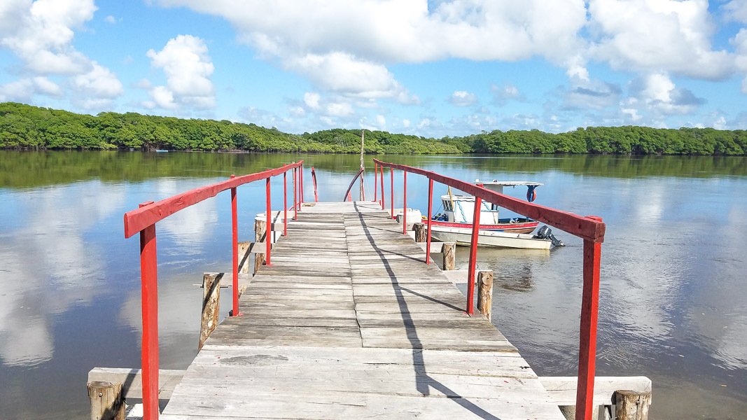
- Ein Pier — Hauptzugang, flankiert von Betonwänden zum Schutz der Hänge
- Schutzgebiete eingezäunt — Wanderwege geöffnet
Wie komme ich dorthin:
Flughafen Porto Seguro: regelmäßige Inlandsflüge und Charterflüge. Shells Airport in der Stadt Caravelas: betreibt regionale Strecken.
Die Stadt Caravelas (20.130 Einwohner) bildet die sogenannte Walküste und auch die Discovery Coast, eine Region mit guter Landwirtschaft, Kultur, Tourismus und Umweltschutz. Es vereint die Gemeinden Porto Seguro, Prado, Alcobaça, New Viçosa und Mucuri.
Die Halbinsel/Insel Penedos befindet sich in der Gemeinde Caravelas im äußersten Süden von Bahia (am Tor zum Albrolhos Marine National Park). Laut der NGO International Conservation ist dies die „[Meeres-] Region mit der höchsten biologischen Vielfalt, die im Südatlantik verzeichnet wurde“ und das fischreichste Gebiet Bahias. Zwischen Juli und Oktober besuchen Buckelwale das Gebiet, um zu brüten und die Kälber zu füttern. Die 18 Meter langen und 40 Tonnen schweren Tiere verzaubern die Besucher mit einer aufregenden Akrobatikshow mit Sprüngen und Pirouetten.
Die Halbinsel/Insel (Höhe 2 bis 6 m) ist in eines der größten Mangrovengebiete Brasiliens integriert. Sie befindet sich am Ende der Halbinsel zwischen den Flüssen Pit und Cupid.
Insgesamt hat die Halbinsel/Insel Penedos eine Fläche von 274,39 Hektar, davon 243,28 Hektar mit Titeln (Farm von Marobá: 13,77 Hektar, Meeresfläche: 17,35 Hektar). Die Insel hat eine gemischte Vegetation aus Gräsern und großen Bäumen. Darüber hinaus gibt es eine Vielzahl von Obstbäumen (Jackfrucht, Mango, Kokosnuss, Orange, Zitrone usw.). An seiner Ostgrenze beträgt das Mangrovengebiet etwa 180 Hektar und der Südhang etwa 40 Hektar. Auf der Westseite befindet sich auch ein Teich mit etwa 10 Hektar.
Die Insel Penedos liegt 10 Minuten mit einem kleinen Boot vom Festland, der Tankstelle, dem Stadtzentrum und vielem mehr entfernt.
Aktuelle Infrastruktur:
- Drei kleine Backsteinhäuser — mit Solarplatten/Batterie für Beleuchtung und Funkkommunikation. Es gibt Dieselmotoren, um Wasser zu pumpen und bei Bedarf Strom zu erzeugen.
- Zwei überdachte Servicehallen — für Traktoren, Werkzeuge, Ausrüstung usw.
- Ein artesischer Brunnen — Süßwasser von ausgezeichneter Qualität, das in einer 10.000 Liter fassenden Glasfaserbox aufbewahrt und über Leitungen verteilt und verbraucht wird
- Viehzucht: Kleinviehzucht. Stall: 200 qm, Holzkonstruktion und Seil/Leine
- Ein Pier — Hauptzugang, flankiert von Betonwänden zum Schutz der Hänge
- Schutzgebiete eingezäunt — Wanderwege geöffnet
Wie komme ich dorthin:
Flughafen Porto Seguro: regelmäßige Inlandsflüge und Charterflüge. Shells Airport in der Stadt Caravelas: betreibt regionale Strecken.
Die Stadt Caravelas (20.130 Einwohner) bildet die sogenannte Walküste und auch die Discovery Coast, eine Region mit guter Landwirtschaft, Kultur, Tourismus und Umweltschutz. Es vereint die Gemeinden Porto Seguro, Prado, Alcobaça, New Viçosa und Mucuri.
Huge private peninsula/island perfect for an eco resort - a dream paradise for nature lovers
The Peninsula/Island of Penedos is located in the municipality of Caravelas in the far south of Bahia (at the gateway of the Albrolhos Marine National Park). According to the NGO International Conservation, this is the “[marine] region with the highest biodiversity recorded in the South Atlantic” and the more fishy area of Bahia. Between the months of July and October, humpback whales visit the area to breed and feed the calves. The animals that measure 18 meters and weigh 40 tons enchant visitors with an exciting acrobatic show, complete with jumps and pirouettes.
The peninsula/island (altitude 2 to 6 m) is integrated into one of the largest mangrove areas of Brazil. It is located at the end of the peninsula between the rivers Pit and Cupid.
In all, the Peninsula/Island of Penedos has 274.39 hectares of area, with 243.28 hectares with titles (farm of Marobá: 13.77 hectares, area of marine: 17.35 hectares). The island has a mixed vegetation of grasses and large trees. In addition, it has a variety of fruit trees (jackfruit, mango, coconut, orange, lemon, etc.). In its eastern boundary, the mangrove area is about 180 acres and the southern slope is about 40 acres. There is also a pond with about 10 hectares on its west side.
The Island of Penedos is located 10 minutes by small boat from the mainland, gas station, town centre, and much more.
Current infrastructure:
- Three small brick houses – with solar plates/battery for lighting and radio communication. There are diesel engines to pump water and generate electricity when needed.
- Two covered service sheds – for tractors, tools, equipment, etc.
- An artesian well – sweet water of excellent quality, stored in glass fiber box of 10,000 liters, piped to distribution and consumption
- Livestock: small-scale cattle breeding. Corral: 200 sqm, wood construction and rope/line
- A pier – main access, flanked by concrete walls to protect the slopes
- Preservation areas fenced – trails open
How to get there:
Porto Seguro Airport: regular domestic flights and charter flights. Shells Airport in the city of Caravelas: operates regional routes.
The city of Caravelas (population: 20,130) makes up the so-called Whale Coast and also the Discovery Coast, a region with good farming, cultural, tourism and environmental preservation. It brings together the municipalities of Porto Seguro, Prado, Alcobaça, New Viçosa and Mucuri.
The Peninsula/Island of Penedos is located in the municipality of Caravelas in the far south of Bahia (at the gateway of the Albrolhos Marine National Park). According to the NGO International Conservation, this is the “[marine] region with the highest biodiversity recorded in the South Atlantic” and the more fishy area of Bahia. Between the months of July and October, humpback whales visit the area to breed and feed the calves. The animals that measure 18 meters and weigh 40 tons enchant visitors with an exciting acrobatic show, complete with jumps and pirouettes.
The peninsula/island (altitude 2 to 6 m) is integrated into one of the largest mangrove areas of Brazil. It is located at the end of the peninsula between the rivers Pit and Cupid.
In all, the Peninsula/Island of Penedos has 274.39 hectares of area, with 243.28 hectares with titles (farm of Marobá: 13.77 hectares, area of marine: 17.35 hectares). The island has a mixed vegetation of grasses and large trees. In addition, it has a variety of fruit trees (jackfruit, mango, coconut, orange, lemon, etc.). In its eastern boundary, the mangrove area is about 180 acres and the southern slope is about 40 acres. There is also a pond with about 10 hectares on its west side.
The Island of Penedos is located 10 minutes by small boat from the mainland, gas station, town centre, and much more.
Current infrastructure:
- Three small brick houses – with solar plates/battery for lighting and radio communication. There are diesel engines to pump water and generate electricity when needed.
- Two covered service sheds – for tractors, tools, equipment, etc.
- An artesian well – sweet water of excellent quality, stored in glass fiber box of 10,000 liters, piped to distribution and consumption
- Livestock: small-scale cattle breeding. Corral: 200 sqm, wood construction and rope/line
- A pier – main access, flanked by concrete walls to protect the slopes
- Preservation areas fenced – trails open
How to get there:
Porto Seguro Airport: regular domestic flights and charter flights. Shells Airport in the city of Caravelas: operates regional routes.
The city of Caravelas (population: 20,130) makes up the so-called Whale Coast and also the Discovery Coast, a region with good farming, cultural, tourism and environmental preservation. It brings together the municipalities of Porto Seguro, Prado, Alcobaça, New Viçosa and Mucuri.
-
Art der Immobilie
Privatinsel
Funktionen
- Wasserblick
- Flussblick
- am Fluss
Erkunden Sie die Gegend
7P94+48 Caravelas, BA, Brazil, Bahia, Brasilien
Auf Google Maps anzeigen
Preis pro sqft
Niedrig
Hoch
Vor 4 Jahren beigetreten
Sie haben sich nach diesem Objekt erkundigt
Der Agent wird sich in Kürze mit Ihnen in Verbindung setzen
Gelistet von
20
Angebote
2022
Beigetreten
Besichtigung mit the agent buchen
Wählen Sie ein Datum und ob Sie eine virtuelle oder persönliche Besichtigung mit dem Makler wünschen.
Bevorzugtes Datum
Art der Tour
Zuletzt aktualisiert
Oktober 2
Erstmalig gelistet
Oktober 2
Ähnliche Immobilien in der Nähe
Neue Angebote in Bahia


Entdecken Sie mehr Häuser zum Verkauf
Bahia, Brasilien Städte
- Häuser zum Verkauf in Trancoso, Brasilien
- Häuser zum Verkauf in Itacaré, Brasilien
- Häuser zum Verkauf in Morro de São Paulo, Brasilien
- Häuser zum Verkauf in Porto Seguro, Brasilien
- Häuser zum Verkauf in Praia do Forte, Brasilien
- Häuser zum Verkauf in Arraial da Ajuda, Brasilien
- Häuser zum Verkauf in Salvador, Brasilien
- Häuser zum Verkauf in Caravelas, Brasilien
- Häuser zum Verkauf in Catu de Abrantes, Brasilien
- Häuser zum Verkauf in Santo André, Brasilien
- Häuser zum Verkauf in Velha Boipeba, Brasilien
- Häuser zum Verkauf in Água Doce, Brasilien
- Häuser zum Verkauf in Alto das Pombas, Brasilien
- Häuser zum Verkauf in Areias, Brasilien
- Häuser zum Verkauf in Barroquinha, Brasilien
- Häuser zum Verkauf in Brotas, Brasilien
- Häuser zum Verkauf in Cairu, Brasilien
- Häuser zum Verkauf in Camaçari, Brasilien
- Häuser zum Verkauf in Canarana, Brasilien
- Häuser zum Verkauf in Canavieiras, Brasilien
Bahia, Brasilien Immobilienarten
Bahia, Brasilien beliebte Suchanfragen
- Immobilien mit Garage in Bahia, Brasilien
- am Strand Immobilien in Bahia, Brasilien
- Immobilien mit Meerblick in Bahia, Brasilien
- am Wasser Immobilien in Bahia, Brasilien
- Immobilien mit Hubschrauberlandeplatz in Bahia, Brasilien
- Immobilien mit Sauna in Bahia, Brasilien
- Immobilien mit Privatstrand in Bahia, Brasilien
- Neubauten Immobilien in Bahia, Brasilien
- Pferdesport Immobilien in Bahia, Brasilien
- Immobilien mit Flussblick in Bahia, Brasilien
Verwandte Leitfäden & Geschichten
Das Vertrauen der führenden Makler der Welt
Die Makler hinter den außergewöhnlichsten Immobilien der Welt inserieren bei JamesEdition.
- Angebote von Sotheby's, Christie's, BARNES und Engel & Völkers
- Jedes Angebot wird vor der Veröffentlichung geprüft
- Verbinden Sie sich direkt mit verifizierten Maklern
Indem Sie fortfahren, akzeptieren Sie unsere Nutzungsbedingungen und Datenschutzrichtlinie.