$698,325
Bauland Lugano Brè
- 10,851 Sqft
- Aktualisiert: Juni 18
- 2
Über die Immobilie
Beschreibung wurde automatisch übersetzt.
Die Beschreibung wird in der Originalsprache angezeigt.
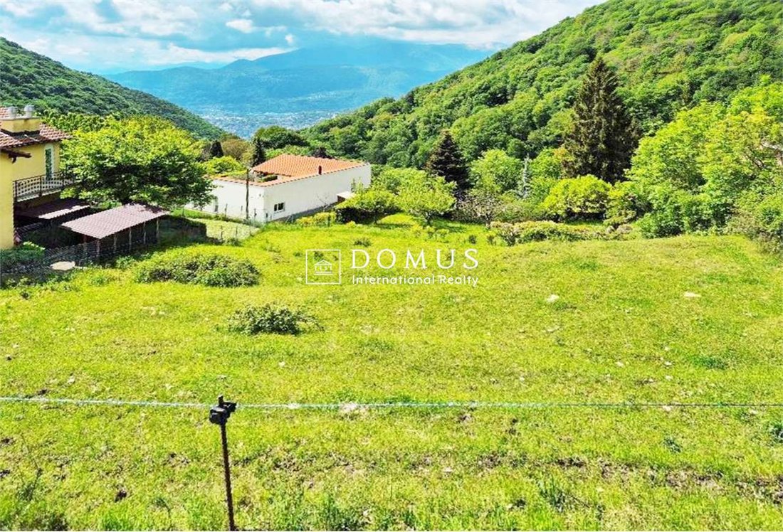
Dies ist eines der wenigen verbliebenen bebaubaren Grundstücke in Brè. Das Grundstück grenzt an den Alpe Bolla Trail und befindet sich in Cranora, am Rande der Stadt.
Es kann mit dem Auto und kleinen bis mittleren Arbeitsfahrzeugen erreicht werden, indem man der Via Pezzora folgt, bis man den Albe Bolla Trail erreicht. Es hat eine rechteckige Form und erstreckt sich über eine Fläche von 1.008
Es kann mit dem Auto und kleinen bis mittleren Arbeitsfahrzeugen erreicht werden, indem man der Via Pezzora folgt, bis man den Albe Bolla Trail erreicht. Es hat eine rechteckige Form und erstreckt sich über eine Fläche von 1.008
This is one of the few remaining buildable plots in Brè. The parcel is adjacent to the Alpe Bolla trail and is located in Cranora, at the edge of town.
It can be reached by car and small-medium work vehicles by following Via Pezzora until reaching the Albe Bolla trail. It is rectangular in shape and covers an area of 1,008 square meters.
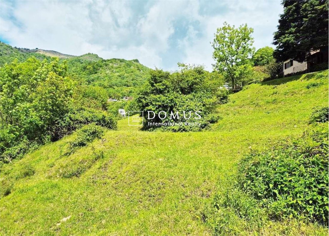
It is sloping and free of buildings.
It is con
It can be reached by car and small-medium work vehicles by following Via Pezzora until reaching the Albe Bolla trail. It is rectangular in shape and covers an area of 1,008 square meters.
It is sloping and free of buildings.
It is con
Dies ist eines der wenigen verbliebenen bebaubaren Grundstücke in Brè. Das Grundstück grenzt an den Alpe Bolla Trail und befindet sich in Cranora, am Rande der Stadt.
Es kann mit dem Auto und kleinen bis mittleren Arbeitsfahrzeugen erreicht werden, indem man der Via Pezzora folgt, bis man den Albe Bolla Trail erreicht. Es hat eine rechteckige Form und erstreckt sich über eine Fläche von 1.008 Quadratmetern.
Es ist schräg und frei von Gebäuden.
Es ist an die städtischen Wasser- und Abwassersysteme angeschlossen.
Die Parameter des Masterplans wurden dem von der Stadt Lugano erstellten Informationsdokument für die Öffentlichkeit (Planung, Umwelt, Energie und Mobilität) entnommen, das einen neuen Vorschlag für das Grundstück in der Wohnzone R2b mit einem Nutzungsindex (IS) = 0,4, einem Belegungsindex (IO) = 30%, einer Mindestgrünfläche in Bezug auf den SEN A. V. = 40% und der maximalen Höhe H = 8,00 m enthält.
Bebaubare Fläche des Grundstücks: 1.008,00 m²
Gesamtnutzung: 1.008,00 qm x 0,4 = ca. 403 qm
Gesamtbelegung: 1.008,00 m² x 30% = ca. 302 m²
Plausible Belegung (muss mit einer Projektstudie definiert werden): 1.008 m² — 259? 25? 27? 52 = 653 qm; effektiv = ca. 65%
Für Zweitwohnungen gibt es keine Einschränkungen; in diesem Zusammenhang führt die Website des Bundesamtes für Raumentwicklung (ARE) die Stadt Lugano in ihrem Wohnungsbestand und ihrem Anteil an Zweitwohnungen unter der Schwelle von 20% auf.
Si tratta di uno dei pochi terreni ancora edificabili a Brè. Die Parzelle grenzt an den Wanderweg Alpe Bolla und befindet sich in der Ortschaft Cranora all’estremità del paese.
Es ist mit Autos und kleinen Arbeitshallen erreichbar, indem Sie die Via Pezzora bis zum Albe Bolla Sentier nehmen, es hat eine rechteckige Form, die Fläche ist 1008 m2.
Resulta en pendenza ed è libero da costruzioni.
Vi è allacciamento alla rete idrica comunale e fognaria.
I parametri di Piano Regolatore sono statestrapolati dal fascicolo information pubblica allestito dalla Città di Lugano Pianificazione, ambiente e energia, mobilità che prevede quale nuova proposta il fondo in zona residenziale R2b con Indice di sfruttamento I. S. = 0.4; Indice di occupazione I. O. = 30%; Area verde minima im Vergleich zu SEN A.V. = 40%, maximale Höhe H = 8,00 ml.
Edificabile del fondo: mq. 1008.00
Gesamtfläche: qm 1008.00 x 0.4 = ca. qm 403
I. Gesamtbelegung: m² 1008.00 x 30% = ca. mq 302
Voraussichtlich (mit Projektstudio zu definieren): 1008 - 259 m2? 25? 27? 52 = mq 653; effektiv = ca. 65%
Non vi sono restrizioni per le abitazioni secondarie; al riguardo il sito internet dell’Ufficio federale dello sviluppo territoriale ARE nell’inventario delle abitazioni e quota di abitazioni secondarie segna la Città di Lugano al di sotto della soglia limite del 20%.
Dies ist der eines wenigen verbliebenen bebaubaren Grundstücks in Brè. Das Grundstück grenzt an den Alpe-Bolla-Wanderweg und befindet sich in Cranora am Ortsrand.
It is available with the car and small bis middle large user vehicles through the Via Pezzora to Alpe-Bolla-Wanderweg. Das rechteckige Grundstück umfasst eine Fläche von 1.008 Quadratmetern.
Es ist abfallend und unbebaut.
Es ist an die städtische Wasser- und Abwasserversorgung angeschlossen.
The parameters of the construction plans from the information document of the city Lugano (planning, environment, energy and mobility). This document contains an new bebauungsvorschlag for the grundstück im wohngebiet R2b with an use index (IS) of 0.4, an employment index (IO) of 30%, an minimum ground area of 40% as AS V. and maximum an building height of 8.00 m.
Bebaubare Fläche: 1.008,00 m²
Gesamtnutzung: 1.008,00 m² x 0,4 = ca. 403 m²
Gesamtbelegung: 1.008,00 m² x 30% = ca. 302 m²
Potenzielle Belegung (wird in einer Projektstudie ermittelt): 1.008 m² - 259 × 25 × 27 × 52 = 653 m²; effektive Belegung = ca. 65%
For two apartments are no restrictions. The website des Bundesamts für Raumordnung (ARE), has the city Lugano in their housing stock and the part of two apartments under the 20% limit.
Es kann mit dem Auto und kleinen bis mittleren Arbeitsfahrzeugen erreicht werden, indem man der Via Pezzora folgt, bis man den Albe Bolla Trail erreicht. Es hat eine rechteckige Form und erstreckt sich über eine Fläche von 1.008 Quadratmetern.
Es ist schräg und frei von Gebäuden.
Es ist an die städtischen Wasser- und Abwassersysteme angeschlossen.
Die Parameter des Masterplans wurden dem von der Stadt Lugano erstellten Informationsdokument für die Öffentlichkeit (Planung, Umwelt, Energie und Mobilität) entnommen, das einen neuen Vorschlag für das Grundstück in der Wohnzone R2b mit einem Nutzungsindex (IS) = 0,4, einem Belegungsindex (IO) = 30%, einer Mindestgrünfläche in Bezug auf den SEN A. V. = 40% und der maximalen Höhe H = 8,00 m enthält.
Bebaubare Fläche des Grundstücks: 1.008,00 m²
Gesamtnutzung: 1.008,00 qm x 0,4 = ca. 403 qm
Gesamtbelegung: 1.008,00 m² x 30% = ca. 302 m²
Plausible Belegung (muss mit einer Projektstudie definiert werden): 1.008 m² — 259? 25? 27? 52 = 653 qm; effektiv = ca. 65%
Für Zweitwohnungen gibt es keine Einschränkungen; in diesem Zusammenhang führt die Website des Bundesamtes für Raumentwicklung (ARE) die Stadt Lugano in ihrem Wohnungsbestand und ihrem Anteil an Zweitwohnungen unter der Schwelle von 20% auf.
Si tratta di uno dei pochi terreni ancora edificabili a Brè. Die Parzelle grenzt an den Wanderweg Alpe Bolla und befindet sich in der Ortschaft Cranora all’estremità del paese.
Es ist mit Autos und kleinen Arbeitshallen erreichbar, indem Sie die Via Pezzora bis zum Albe Bolla Sentier nehmen, es hat eine rechteckige Form, die Fläche ist 1008 m2.
Resulta en pendenza ed è libero da costruzioni.
Vi è allacciamento alla rete idrica comunale e fognaria.
I parametri di Piano Regolatore sono statestrapolati dal fascicolo information pubblica allestito dalla Città di Lugano Pianificazione, ambiente e energia, mobilità che prevede quale nuova proposta il fondo in zona residenziale R2b con Indice di sfruttamento I. S. = 0.4; Indice di occupazione I. O. = 30%; Area verde minima im Vergleich zu SEN A.V. = 40%, maximale Höhe H = 8,00 ml.
Edificabile del fondo: mq. 1008.00
Gesamtfläche: qm 1008.00 x 0.4 = ca. qm 403
I. Gesamtbelegung: m² 1008.00 x 30% = ca. mq 302
Voraussichtlich (mit Projektstudio zu definieren): 1008 - 259 m2? 25? 27? 52 = mq 653; effektiv = ca. 65%
Non vi sono restrizioni per le abitazioni secondarie; al riguardo il sito internet dell’Ufficio federale dello sviluppo territoriale ARE nell’inventario delle abitazioni e quota di abitazioni secondarie segna la Città di Lugano al di sotto della soglia limite del 20%.
Dies ist der eines wenigen verbliebenen bebaubaren Grundstücks in Brè. Das Grundstück grenzt an den Alpe-Bolla-Wanderweg und befindet sich in Cranora am Ortsrand.
It is available with the car and small bis middle large user vehicles through the Via Pezzora to Alpe-Bolla-Wanderweg. Das rechteckige Grundstück umfasst eine Fläche von 1.008 Quadratmetern.
Es ist abfallend und unbebaut.
Es ist an die städtische Wasser- und Abwasserversorgung angeschlossen.
The parameters of the construction plans from the information document of the city Lugano (planning, environment, energy and mobility). This document contains an new bebauungsvorschlag for the grundstück im wohngebiet R2b with an use index (IS) of 0.4, an employment index (IO) of 30%, an minimum ground area of 40% as AS V. and maximum an building height of 8.00 m.
Bebaubare Fläche: 1.008,00 m²
Gesamtnutzung: 1.008,00 m² x 0,4 = ca. 403 m²
Gesamtbelegung: 1.008,00 m² x 30% = ca. 302 m²
Potenzielle Belegung (wird in einer Projektstudie ermittelt): 1.008 m² - 259 × 25 × 27 × 52 = 653 m²; effektive Belegung = ca. 65%
For two apartments are no restrictions. The website des Bundesamts für Raumordnung (ARE), has the city Lugano in their housing stock and the part of two apartments under the 20% limit.
This is one of the few remaining buildable plots in Brè. The parcel is adjacent to the Alpe Bolla trail and is located in Cranora, at the edge of town.
It can be reached by car and small-medium work vehicles by following Via Pezzora until reaching the Albe Bolla trail. It is rectangular in shape and covers an area of 1,008 square meters.
It is sloping and free of buildings.
It is connected to the municipal water and sewer systems.
The Master Plan parameters were taken from the public information document prepared by the City of Lugano (Planning, Environment, Energy, and Mobility), which includes a new proposal for the land in the R2b residential zone with an Exploitation Index (IS) = 0.4; Occupancy Index (IO) = 30%; Minimum green area with respect to the SEN A. V. = 40%, maximum height H = 8.00 m.
Land buildable area: 1,008.00 sq. m.
Total utilization: 1,008.00 sq. m. x 0.4 = approx. 403 sq. m.
Total occupancy: 1,008.00 sq. m. x 30% = approx. 302 sq. m.
Plausible occupancy (to be defined with a project study): 1,008 sq. m. - 259 ? 25 ? 27 ? 52 = 653 sq. m.; effective = approx. 65%
There are no restrictions for second homes; in this regard, the website of the Federal Office for Spatial Development (ARE) lists the City of Lugano below the 20% threshold in its inventory of dwellings and share of second homes.
Si tratta di uno dei pochi terreni ancora edificabili a Brè. La parcella è adiacente il sentiero Alpe Bolla ed è ubicata in località Cranora all’estremità del paese.
È raggiungibile con autoveicoli e piccoli-medi mezzi di lavoro percorrendo la Via Pezzora fino a raggiungere il sentiero Albe Bolla, è di forma rettangolare, la superficie è di mq. 1008.
Risulta in pendenza ed è libero da costruzioni.
Vi è allacciamento alla rete idrica comunale e fognaria.
I parametri di Piano Regolatore sono stati estrapolati dal fascicolo informazione pubblica allestito dalla Città di Lugano Pianificazione, ambiente e energia, mobilità che prevede quale nuova proposta il fondo in zona residenziale R2b con Indice di sfruttamento I. S. = 0.4; Indice di occupazione I. O. = 30%; Area verde minima rispetto alla SEN A. V. = 40%, altezza massima H = ml. 8.00.
Superficie edificabile del fondo: mq. 1008.00
I.s. sfruttamento totale: mq. 1008.00 x 0.4 = ca. mq 403
I.o occupazione totale: mq. 1008.00 x 30% = ca. mq 302
A.v. plausibile (da definire con studio di progetto): mq. 1008 - 259 ? 25 ? 27 ? 52 = mq 653; effettiva = ca. 65%
Non vi sono restrizioni per le abitazioni secondarie; al riguardo il sito internet dell’Ufficio federale dello sviluppo territoriale ARE nell’inventario delle abitazioni e quota di abitazioni secondarie segna la Città di Lugano al di sotto della soglia limite del 20%.
Dies ist eines der wenigen verbliebenen bebaubaren Grundstücke in Brè. Das Grundstück grenzt an den Alpe-Bolla-Wanderweg und befindet sich in Cranora am Ortsrand.
Es ist mit dem Auto und kleinen bis mittelgroßen Nutzfahrzeugen über die Via Pezzora bis zum Alpe-Bolla-Wanderweg erreichbar. Das rechteckige Grundstück umfasst eine Fläche von 1.008 Quadratmetern.
Es ist abfallend und unbebaut.
Es ist an die städtische Wasser- und Abwasserversorgung angeschlossen.
Die Parameter des Bebauungsplans stammen aus dem Informationsdokument der Stadt Lugano (Planung, Umwelt, Energie und Mobilität). Dieses Dokument enthält einen neuen Bebauungsvorschlag für das Grundstück im Wohngebiet R2b mit einem Nutzungsindex (IS) von 0,4, einem Belegungsindex (IO) von 30 %, einer Mindestgrünfläche von 40 % gemäß SEN A. V. und einer maximalen Gebäudehöhe von 8,00 m.
Bebaubare Fläche: 1.008,00 m²
Gesamtnutzung: 1.008,00 m² x 0,4 = ca. 403 m²
Gesamtbelegung: 1.008,00 m² x 30 % = ca. 302 m²
Potenzielle Belegung (wird in einer Projektstudie ermittelt): 1.008 m² - 259 × 25 × 27 × 52 = 653 m²; effektive Belegung = ca. 65 %
Für Zweitwohnungen bestehen keine Beschränkungen. Die Website des Bundesamts für Raumordnung (ARE) führt die Stadt Lugano in ihrem Wohnungsbestand und dem Anteil der Zweitwohnungen unterhalb der 20%-Grenze.
It can be reached by car and small-medium work vehicles by following Via Pezzora until reaching the Albe Bolla trail. It is rectangular in shape and covers an area of 1,008 square meters.
It is sloping and free of buildings.
It is connected to the municipal water and sewer systems.
The Master Plan parameters were taken from the public information document prepared by the City of Lugano (Planning, Environment, Energy, and Mobility), which includes a new proposal for the land in the R2b residential zone with an Exploitation Index (IS) = 0.4; Occupancy Index (IO) = 30%; Minimum green area with respect to the SEN A. V. = 40%, maximum height H = 8.00 m.
Land buildable area: 1,008.00 sq. m.
Total utilization: 1,008.00 sq. m. x 0.4 = approx. 403 sq. m.
Total occupancy: 1,008.00 sq. m. x 30% = approx. 302 sq. m.
Plausible occupancy (to be defined with a project study): 1,008 sq. m. - 259 ? 25 ? 27 ? 52 = 653 sq. m.; effective = approx. 65%
There are no restrictions for second homes; in this regard, the website of the Federal Office for Spatial Development (ARE) lists the City of Lugano below the 20% threshold in its inventory of dwellings and share of second homes.
Si tratta di uno dei pochi terreni ancora edificabili a Brè. La parcella è adiacente il sentiero Alpe Bolla ed è ubicata in località Cranora all’estremità del paese.
È raggiungibile con autoveicoli e piccoli-medi mezzi di lavoro percorrendo la Via Pezzora fino a raggiungere il sentiero Albe Bolla, è di forma rettangolare, la superficie è di mq. 1008.
Risulta in pendenza ed è libero da costruzioni.
Vi è allacciamento alla rete idrica comunale e fognaria.
I parametri di Piano Regolatore sono stati estrapolati dal fascicolo informazione pubblica allestito dalla Città di Lugano Pianificazione, ambiente e energia, mobilità che prevede quale nuova proposta il fondo in zona residenziale R2b con Indice di sfruttamento I. S. = 0.4; Indice di occupazione I. O. = 30%; Area verde minima rispetto alla SEN A. V. = 40%, altezza massima H = ml. 8.00.
Superficie edificabile del fondo: mq. 1008.00
I.s. sfruttamento totale: mq. 1008.00 x 0.4 = ca. mq 403
I.o occupazione totale: mq. 1008.00 x 30% = ca. mq 302
A.v. plausibile (da definire con studio di progetto): mq. 1008 - 259 ? 25 ? 27 ? 52 = mq 653; effettiva = ca. 65%
Non vi sono restrizioni per le abitazioni secondarie; al riguardo il sito internet dell’Ufficio federale dello sviluppo territoriale ARE nell’inventario delle abitazioni e quota di abitazioni secondarie segna la Città di Lugano al di sotto della soglia limite del 20%.
Dies ist eines der wenigen verbliebenen bebaubaren Grundstücke in Brè. Das Grundstück grenzt an den Alpe-Bolla-Wanderweg und befindet sich in Cranora am Ortsrand.
Es ist mit dem Auto und kleinen bis mittelgroßen Nutzfahrzeugen über die Via Pezzora bis zum Alpe-Bolla-Wanderweg erreichbar. Das rechteckige Grundstück umfasst eine Fläche von 1.008 Quadratmetern.
Es ist abfallend und unbebaut.
Es ist an die städtische Wasser- und Abwasserversorgung angeschlossen.
Die Parameter des Bebauungsplans stammen aus dem Informationsdokument der Stadt Lugano (Planung, Umwelt, Energie und Mobilität). Dieses Dokument enthält einen neuen Bebauungsvorschlag für das Grundstück im Wohngebiet R2b mit einem Nutzungsindex (IS) von 0,4, einem Belegungsindex (IO) von 30 %, einer Mindestgrünfläche von 40 % gemäß SEN A. V. und einer maximalen Gebäudehöhe von 8,00 m.
Bebaubare Fläche: 1.008,00 m²
Gesamtnutzung: 1.008,00 m² x 0,4 = ca. 403 m²
Gesamtbelegung: 1.008,00 m² x 30 % = ca. 302 m²
Potenzielle Belegung (wird in einer Projektstudie ermittelt): 1.008 m² - 259 × 25 × 27 × 52 = 653 m²; effektive Belegung = ca. 65 %
Für Zweitwohnungen bestehen keine Beschränkungen. Die Website des Bundesamts für Raumordnung (ARE) führt die Stadt Lugano in ihrem Wohnungsbestand und dem Anteil der Zweitwohnungen unterhalb der 20%-Grenze.
-
Art der Immobilie
Land
-
Preis/Quadratfuß
$64
Funktionen
- Garten
- Bergblick
- Office
Erkunden Sie die Gegend
via pezzora, Lugano, Tessin, Schweiz
Auf Google Maps anzeigen
Preis pro sqft
Niedrig
Hoch
Vor 2 Jahren beigetreten
Sie haben sich nach diesem Objekt erkundigt
Der Agent wird sich in Kürze mit Ihnen in Verbindung setzen
Gelistet von
180
Angebote
2024
Beigetreten
Besichtigung mit the agent buchen
Wählen Sie ein Datum und ob Sie eine virtuelle oder persönliche Besichtigung mit dem Makler wünschen.
Bevorzugtes Datum
Art der Tour
Zuletzt aktualisiert
Juni 18
Erstmalig gelistet
Februar 25
Angebotsreferenz
9099_1_6102_V001271
Ähnliche Immobilien in der Nähe
Neue Angebote in Lugano

Entdecken Sie mehr Häuser zum Verkauf
Lugano, Tessin, Schweiz Immobilienarten
- Wohnungen zum Verkauf in Lugano, Tessin, Schweiz
- Villen zum Verkauf in Lugano, Tessin, Schweiz
- Häuser zum Verkauf in Lugano, Tessin, Schweiz
- Penthouses zum Verkauf in Lugano, Tessin, Schweiz
- Land zum Verkauf in Lugano, Tessin, Schweiz
- Landhaus zum Verkauf in Lugano, Tessin, Schweiz
- Eigentumswohnungen zum Verkauf in Lugano, Tessin, Schweiz
Lugano, Tessin, Schweiz beliebte Suchanfragen
- Panorama Immobilien in Lugano, Tessin, Schweiz
- Immobilien mit Meerblick in Lugano, Tessin, Schweiz
- Immobilien mit Seeblick in Lugano, Tessin, Schweiz
- Immobilien mit Flussblick in Lugano, Tessin, Schweiz
- Immobilien mit Garten in Lugano, Tessin, Schweiz
- Gesicherte Wohnanlage Immobilien in Lugano, Tessin, Schweiz
- am Wasser Immobilien in Lugano, Tessin, Schweiz
- Anlageimmobilie Immobilien in Lugano, Tessin, Schweiz
- Neubauten Immobilien in Lugano, Tessin, Schweiz
- Immobilien mit Pool in Lugano, Tessin, Schweiz
- Immobilien mit Garage in Lugano, Tessin, Schweiz
- Luxusvilla Immobilien in Lugano, Tessin, Schweiz
- Immobilien mit Privatstrand in Lugano, Tessin, Schweiz
- am See Immobilien in Lugano, Tessin, Schweiz
- am Fluss Immobilien in Lugano, Tessin, Schweiz
- Immobilien mit Hallenbad in Lugano, Tessin, Schweiz
- Immobilien mit Wasserblick in Lugano, Tessin, Schweiz
Lugano, Tessin, Schweiz nachbarschaften
- Häuser zum Verkauf in Castagnola, Lugano, Tessin
- Häuser zum Verkauf in Brè-Aldesago, Lugano, Tessin
- Häuser zum Verkauf in Carona, Lugano, Tessin
- Häuser zum Verkauf in Pregassona, Lugano, Tessin
- Häuser zum Verkauf in Davesco-Soragno, Lugano, Tessin
- Häuser zum Verkauf in Villa Luganese, Lugano, Tessin
- Häuser zum Verkauf in Sonvico, Lugano, Schweiz
- Häuser zum Verkauf in Cadro, Lugano, Schweiz
- Häuser zum Verkauf in Barbengo, Lugano, Schweiz
- Häuser zum Verkauf in Carabbia, Lugano, Schweiz
- Häuser zum Verkauf in Cureggia, Lugano, Tessin
- Häuser zum Verkauf in Cimadera
- Häuser zum Verkauf in Gandria
Verwandte Leitfäden & Geschichten
Das Vertrauen der führenden Makler der Welt
Die Makler hinter den außergewöhnlichsten Immobilien der Welt inserieren bei JamesEdition.
- Angebote von Sotheby's, Christie's, BARNES und Engel & Völkers
- Jedes Angebot wird vor der Veröffentlichung geprüft
- Verbinden Sie sich direkt mit verifizierten Maklern
Indem Sie fortfahren, akzeptieren Sie unsere Nutzungsbedingungen und Datenschutzrichtlinie.