$1,500,000
Île de Penedo, Brésil
- 678.0 Ac lot
- Mis à jour: Octobre 2
- 14
À propos de la propriété
La description a été traduite automatiquement.
La description est affichée dans la langue d'origine.
Immense péninsule/île privée parfaite pour un complexe écologique - un paradis de rêve pour les amoureux de la nature
La péninsule/île de Penedos est située dans la municipalité de Caravelas, à l’extrême sud de Bahia (aux portes du parc national marin d’Albrolhos). Selon l’ONG International Conservation, il s’agit de la « région [marine] la plus riche en biodiversité enregistrée dans
La péninsule/île de Penedos est située dans la municipalité de Caravelas, à l’extrême sud de Bahia (aux portes du parc national marin d’Albrolhos). Selon l’ONG International Conservation, il s’agit de la « région [marine] la plus riche en biodiversité enregistrée dans
Huge private peninsula/island perfect for an eco resort - a dream paradise for nature lovers
The Peninsula/Island of Penedos is located in the municipality of Caravelas in the far south of Bahia (at the gateway of the Albrolhos Marine National Park). According to the NGO International Conservation, this is the “[marine] region with the highest biodiversity recorded in the South Atlantic”
The Peninsula/Island of Penedos is located in the municipality of Caravelas in the far south of Bahia (at the gateway of the Albrolhos Marine National Park). According to the NGO International Conservation, this is the “[marine] region with the highest biodiversity recorded in the South Atlantic”
Immense péninsule/île privée parfaite pour un complexe écologique - un paradis de rêve pour les amoureux de la nature
La péninsule/île de Penedos est située dans la municipalité de Caravelas, à l’extrême sud de Bahia (aux portes du parc national marin d’Albrolhos). Selon l’ONG International Conservation, il s’agit de la « région [marine] la plus riche en biodiversité enregistrée dans l’Atlantique Sud » et de la zone la plus poissonneuse de Bahia. Entre les mois de juillet et octobre, les baleines à bosse visitent la région pour se reproduire et nourrir les petits. Les animaux qui mesurent 18 mètres et pèsent 40 tonnes enchantent les visiteurs avec un spectacle acrobatique passionnant, agrémenté de sauts et de pirouettes.
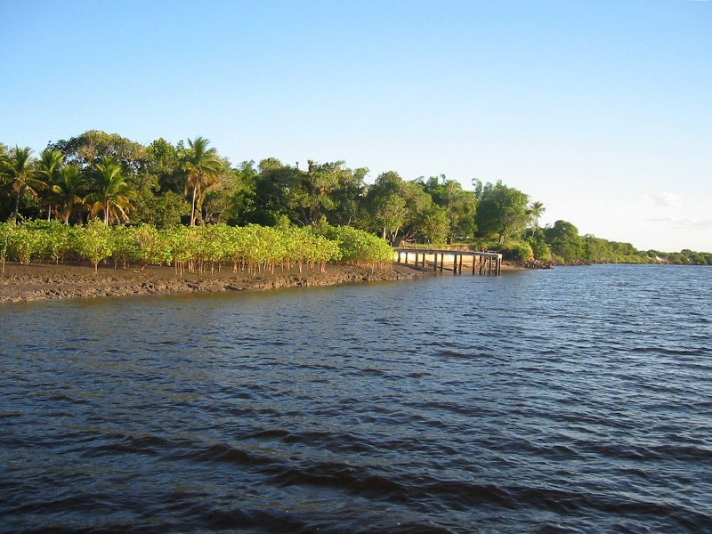
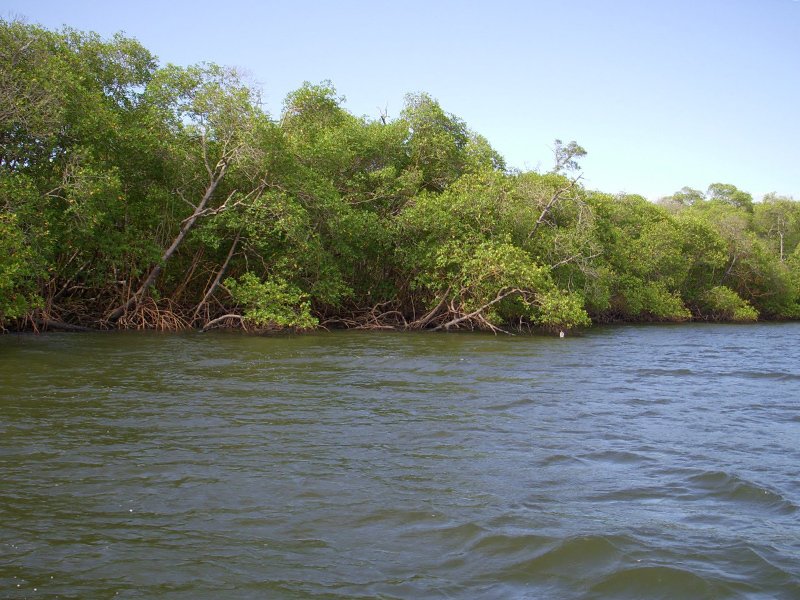
La péninsule/île (altitude de 2 à 6 m) est intégrée dans l’une des plus grandes zones de mangrove du Brésil. Il est situé à l’extrémité de la péninsule entre les rivières Pit et Cupidon.
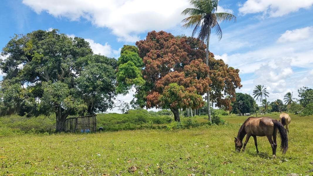
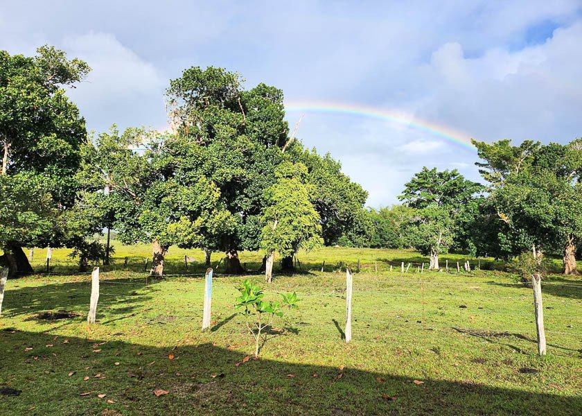
Au total, la péninsule/île de Penedos a une superficie de 274,39 hectares, dont 243,28 hectares avec titres (ferme de Marobá : 13,77 hectares, zone marine : 17,35 hectares). L’île possède une végétation mixte composée de graminées et de grands arbres. De plus, il possède une variété d’arbres fruitiers (jacquier, manguier, cocotier, oranger, citron, etc.). À sa limite orientale, la zone de mangrove s’étend sur environ 180 acres et le versant sud sur environ 40 acres. Il y a également un étang d’environ 10 hectares sur son côté ouest.
L’île de Penedos est située à 10 minutes en petit bateau du continent, de la station-service, du centre-ville et bien plus encore.
Infrastructure actuelle :
- Trois petites maisons en briques, équipées de plaques solaires et de batteries pour l’éclairage et la communication radio. Il existe des moteurs diesel pour pomper de l’eau et produire de l’électricité en cas de besoin.
- Deux hangars de service couverts : pour les tracteurs, les outils, l’équipement, etc.
- Un puits artésien — eau douce d’excellente qualité, stockée dans une boîte en fibre de verre de 10 000 litres, acheminée vers la distribution et la consommation
- Élevage : élevage bovin à petite échelle. Corral : 200 m², construction en bois et corde/ligne
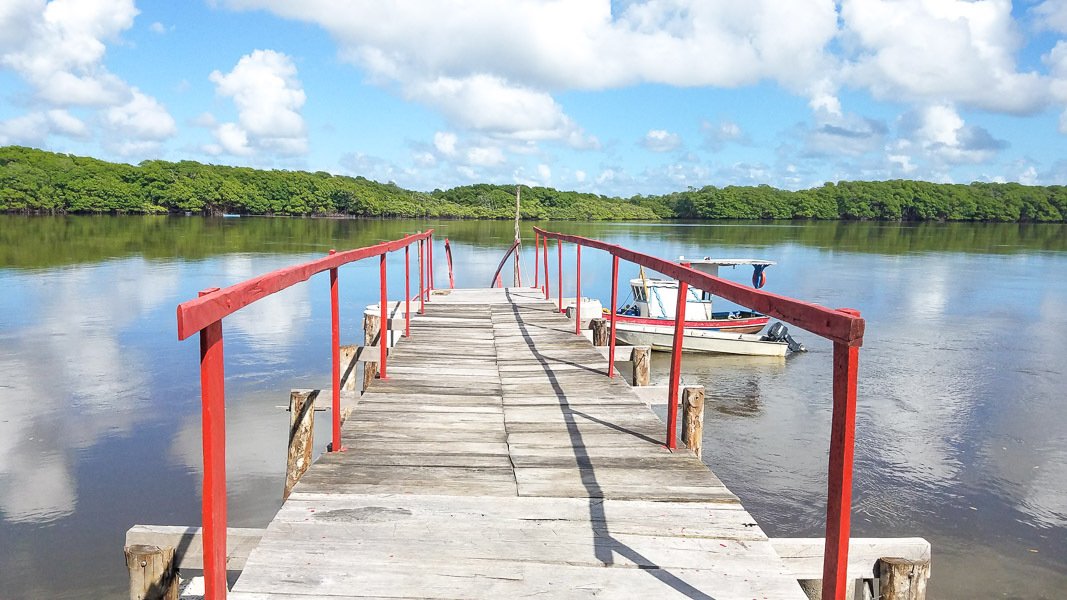
- Une jetée, accès principal, flanquée de murs en béton pour protéger les pentes
- Zones de préservation clôturées — sentiers ouverts
Comment s’y rendre :
Aéroport de Porto Seguro : vols intérieurs réguliers et vols charters. Aéroport Shells de la ville de Caravelas : assure des liaisons régionales.
La ville de Caravelas (20 130 habitants) constitue la soi-disant Côte des Baleines ainsi que la Côte de la Découverte, une région où l’agriculture, la culture, le tourisme et l’environnement sont bien préservés. Il regroupe les municipalités de Porto Seguro, Prado, Alcobaça, New Viçosa et Mucuri.
La péninsule/île de Penedos est située dans la municipalité de Caravelas, à l’extrême sud de Bahia (aux portes du parc national marin d’Albrolhos). Selon l’ONG International Conservation, il s’agit de la « région [marine] la plus riche en biodiversité enregistrée dans l’Atlantique Sud » et de la zone la plus poissonneuse de Bahia. Entre les mois de juillet et octobre, les baleines à bosse visitent la région pour se reproduire et nourrir les petits. Les animaux qui mesurent 18 mètres et pèsent 40 tonnes enchantent les visiteurs avec un spectacle acrobatique passionnant, agrémenté de sauts et de pirouettes.
La péninsule/île (altitude de 2 à 6 m) est intégrée dans l’une des plus grandes zones de mangrove du Brésil. Il est situé à l’extrémité de la péninsule entre les rivières Pit et Cupidon.
Au total, la péninsule/île de Penedos a une superficie de 274,39 hectares, dont 243,28 hectares avec titres (ferme de Marobá : 13,77 hectares, zone marine : 17,35 hectares). L’île possède une végétation mixte composée de graminées et de grands arbres. De plus, il possède une variété d’arbres fruitiers (jacquier, manguier, cocotier, oranger, citron, etc.). À sa limite orientale, la zone de mangrove s’étend sur environ 180 acres et le versant sud sur environ 40 acres. Il y a également un étang d’environ 10 hectares sur son côté ouest.
L’île de Penedos est située à 10 minutes en petit bateau du continent, de la station-service, du centre-ville et bien plus encore.
Infrastructure actuelle :
- Trois petites maisons en briques, équipées de plaques solaires et de batteries pour l’éclairage et la communication radio. Il existe des moteurs diesel pour pomper de l’eau et produire de l’électricité en cas de besoin.
- Deux hangars de service couverts : pour les tracteurs, les outils, l’équipement, etc.
- Un puits artésien — eau douce d’excellente qualité, stockée dans une boîte en fibre de verre de 10 000 litres, acheminée vers la distribution et la consommation
- Élevage : élevage bovin à petite échelle. Corral : 200 m², construction en bois et corde/ligne
- Une jetée, accès principal, flanquée de murs en béton pour protéger les pentes
- Zones de préservation clôturées — sentiers ouverts
Comment s’y rendre :
Aéroport de Porto Seguro : vols intérieurs réguliers et vols charters. Aéroport Shells de la ville de Caravelas : assure des liaisons régionales.
La ville de Caravelas (20 130 habitants) constitue la soi-disant Côte des Baleines ainsi que la Côte de la Découverte, une région où l’agriculture, la culture, le tourisme et l’environnement sont bien préservés. Il regroupe les municipalités de Porto Seguro, Prado, Alcobaça, New Viçosa et Mucuri.
Huge private peninsula/island perfect for an eco resort - a dream paradise for nature lovers
The Peninsula/Island of Penedos is located in the municipality of Caravelas in the far south of Bahia (at the gateway of the Albrolhos Marine National Park). According to the NGO International Conservation, this is the “[marine] region with the highest biodiversity recorded in the South Atlantic” and the more fishy area of Bahia. Between the months of July and October, humpback whales visit the area to breed and feed the calves. The animals that measure 18 meters and weigh 40 tons enchant visitors with an exciting acrobatic show, complete with jumps and pirouettes.
The peninsula/island (altitude 2 to 6 m) is integrated into one of the largest mangrove areas of Brazil. It is located at the end of the peninsula between the rivers Pit and Cupid.
In all, the Peninsula/Island of Penedos has 274.39 hectares of area, with 243.28 hectares with titles (farm of Marobá: 13.77 hectares, area of marine: 17.35 hectares). The island has a mixed vegetation of grasses and large trees. In addition, it has a variety of fruit trees (jackfruit, mango, coconut, orange, lemon, etc.). In its eastern boundary, the mangrove area is about 180 acres and the southern slope is about 40 acres. There is also a pond with about 10 hectares on its west side.
The Island of Penedos is located 10 minutes by small boat from the mainland, gas station, town centre, and much more.
Current infrastructure:
- Three small brick houses – with solar plates/battery for lighting and radio communication. There are diesel engines to pump water and generate electricity when needed.
- Two covered service sheds – for tractors, tools, equipment, etc.
- An artesian well – sweet water of excellent quality, stored in glass fiber box of 10,000 liters, piped to distribution and consumption
- Livestock: small-scale cattle breeding. Corral: 200 sqm, wood construction and rope/line
- A pier – main access, flanked by concrete walls to protect the slopes
- Preservation areas fenced – trails open
How to get there:
Porto Seguro Airport: regular domestic flights and charter flights. Shells Airport in the city of Caravelas: operates regional routes.
The city of Caravelas (population: 20,130) makes up the so-called Whale Coast and also the Discovery Coast, a region with good farming, cultural, tourism and environmental preservation. It brings together the municipalities of Porto Seguro, Prado, Alcobaça, New Viçosa and Mucuri.
The Peninsula/Island of Penedos is located in the municipality of Caravelas in the far south of Bahia (at the gateway of the Albrolhos Marine National Park). According to the NGO International Conservation, this is the “[marine] region with the highest biodiversity recorded in the South Atlantic” and the more fishy area of Bahia. Between the months of July and October, humpback whales visit the area to breed and feed the calves. The animals that measure 18 meters and weigh 40 tons enchant visitors with an exciting acrobatic show, complete with jumps and pirouettes.
The peninsula/island (altitude 2 to 6 m) is integrated into one of the largest mangrove areas of Brazil. It is located at the end of the peninsula between the rivers Pit and Cupid.
In all, the Peninsula/Island of Penedos has 274.39 hectares of area, with 243.28 hectares with titles (farm of Marobá: 13.77 hectares, area of marine: 17.35 hectares). The island has a mixed vegetation of grasses and large trees. In addition, it has a variety of fruit trees (jackfruit, mango, coconut, orange, lemon, etc.). In its eastern boundary, the mangrove area is about 180 acres and the southern slope is about 40 acres. There is also a pond with about 10 hectares on its west side.
The Island of Penedos is located 10 minutes by small boat from the mainland, gas station, town centre, and much more.
Current infrastructure:
- Three small brick houses – with solar plates/battery for lighting and radio communication. There are diesel engines to pump water and generate electricity when needed.
- Two covered service sheds – for tractors, tools, equipment, etc.
- An artesian well – sweet water of excellent quality, stored in glass fiber box of 10,000 liters, piped to distribution and consumption
- Livestock: small-scale cattle breeding. Corral: 200 sqm, wood construction and rope/line
- A pier – main access, flanked by concrete walls to protect the slopes
- Preservation areas fenced – trails open
How to get there:
Porto Seguro Airport: regular domestic flights and charter flights. Shells Airport in the city of Caravelas: operates regional routes.
The city of Caravelas (population: 20,130) makes up the so-called Whale Coast and also the Discovery Coast, a region with good farming, cultural, tourism and environmental preservation. It brings together the municipalities of Porto Seguro, Prado, Alcobaça, New Viçosa and Mucuri.
-
Type de propriété
Île privée
Caractéristiques
- Vue sur la mer
- Vue sur la rivière
- Front de rivière
Explorez le secteur
7P94+48 Caravelas, BA, Brazil, Bahia, Brésil
Voir sur Google Maps
Prix par sqft
Faible
Élevé
Inscrit il y a 4 ans
Vous vous êtes renseigné sur ce bien
L'agent vous contactera bientôt par
Publié par
19
Annonces
2022
Inscrit
Réserver une visite avec the agent
Choisissez une date et si vous souhaitez une visite virtuelle ou en personne avec l’agent.
Date préférée
Type de visite

Dernière mise à jour
Octobre 2
Première mise en ligne
Octobre 2
Propriétés similaires à proximité
Nouvelles annonces à Bahia


Explorez plus de biens à vendre
Bahia, Brésil Villes
- Maisons à vendre à Trancoso, Brésil
- Maisons à vendre à Itacaré, Brésil
- Maisons à vendre à Salvador, Brésil
- Maisons à vendre à Santo André, Brésil
- Maisons à vendre à Praia do Forte, Brésil
- Maisons à vendre à Porto Seguro, Brésil
- Maisons à vendre à Arraial d'Ajuda, Brésil
- Maisons à vendre à Lauro de Freitas, Brésil
- Maisons à vendre à Morro de São Paulo, Brésil
- Maisons à vendre à Caravelas, Brésil
- Maisons à vendre à Catu de Abrantes, Brésil
- Maisons à vendre à Patamares, Brésil
- Maisons à vendre à Velha Boipeba, Brésil
- Maisons à vendre à Água Doce, Brésil
- Maisons à vendre à Alto das Pombas, Brésil
- Maisons à vendre à Areias, Brésil
- Maisons à vendre à Barroquinha, Brésil
- Maisons à vendre à Brotas, Brésil
- Maisons à vendre à Cairu, Brésil
- Maisons à vendre à Camaçari, Brésil
Bahia, Brésil types de propriétés
Bahia, Brésil Recherches populaires
- Propriétés avec Garage à Bahia, Brésil
- Plage propriétés à Bahia, Brésil
- Vue sur la mer propriétés à Bahia, Brésil
- Au bord de l’eau propriétés à Bahia, Brésil
- Propriétés avec Sauna à Bahia, Brésil
- Propriétés avec Héliport à Bahia, Brésil
- Propriétés avec Plage privée à Bahia, Brésil
- Vue sur la ville propriétés à Bahia, Brésil
- Constructions neuves propriétés à Bahia, Brésil
- Équestre propriétés à Bahia, Brésil
- Vue sur la rivière propriétés à Bahia, Brésil
Guides et histoires connexes
La confiance des plus grands courtiers du monde
Les agents des propriétés les plus exceptionnelles du monde publient sur JamesEdition.
- Des annonces de Sotheby's, Christie's, BARNES et Engel & Völkers
- Chaque annonce est vérifiée avant sa mise en ligne
- Contactez directement des agents vérifiés
En continuant, vous acceptez nos Conditions et notre Politique de confidentialité.